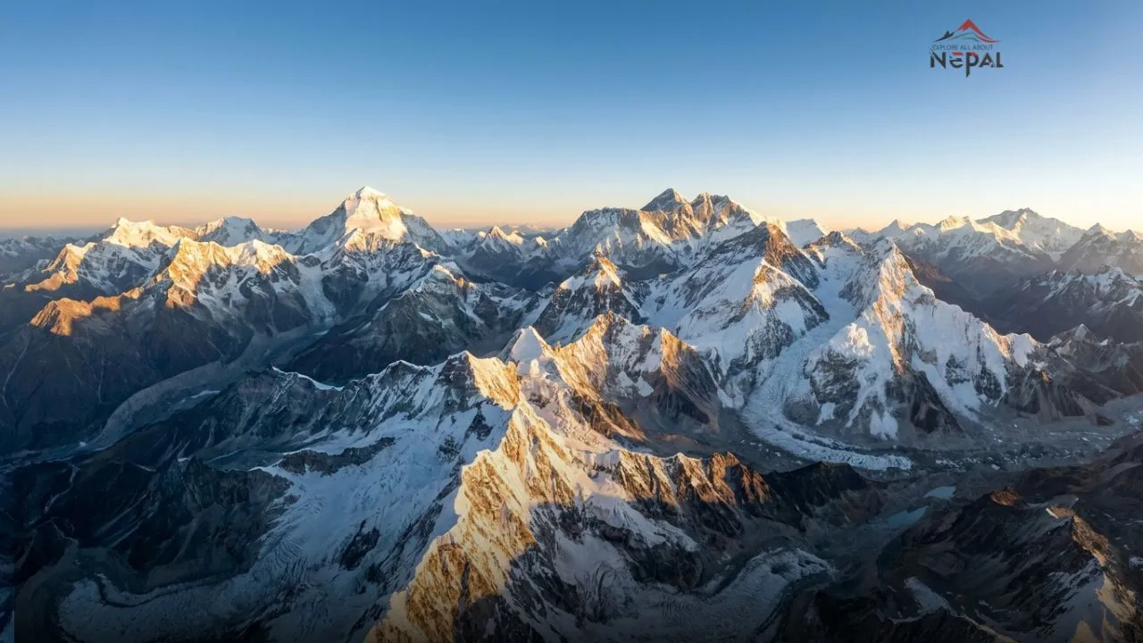
Everyone knows Everest. Most people who’ve researched Nepal trekking know Annapurna and Manaslu. But Nepal is home to eight of the fourteen mountains on Earth that exceed 8,000 meters and for six of them, the average Western traveler couldn’t name them, locate them on a map, or tell you a single fact about their climbing history.
This is the guide that fixes that. Not a dry list of altitudes, but the story of what makes each mountain genuinely remarkable and why the six that live in Everest’s shadow deserve to be known on their own terms.
First: The Complete List of the World’s 14 Eight-Thousanders
Before the Nepal-specific breakdown, the full list because understanding which peaks are and aren’t in Nepal is the foundation of everything else here.
| Rank | Mountain | Height | Country |
|---|---|---|---|
| 1 | Everest (Sagarmatha) | 8,849m | Nepal/Tibet |
| 2 | K2 | 8,611m | Pakistan/China |
| 3 | Kangchenjunga | 8,586m | Nepal/India |
| 4 | Lhotse | 8,516m | Nepal/Tibet |
| 5 | Makalu | 8,485m | Nepal/Tibet |
| 6 | Cho Oyu | 8,188m | Nepal/Tibet |
| 7 | Dhaulagiri I | 8,167m | Nepal |
| 8 | Manaslu | 8,163m | Nepal |
| 9 | Nanga Parbat | 8,126m | Pakistan |
| 10 | Annapurna I | 8,091m | Nepal |
| 11 | Gasherbrum I | 8,080m | Pakistan/China |
| 12 | Broad Peak | 8,051m | Pakistan/China |
| 13 | Gasherbrum II | 8,035m | Pakistan/China |
| 14 | Shishapangma | 8,027m | Tibet (China) |
Nepal’s eight: Everest, Kangchenjunga, Lhotse, Makalu, Cho Oyu, Dhaulagiri I, Manaslu, and Annapurna I.
The other six K2, Nanga Parbat, Gasherbrum I, Broad Peak, Gasherbrum II, and Shishapangma are in Pakistan or Chinese-controlled Tibet, outside Nepal’s borders entirely.

Nepal’s 8 Highest Mountains in Nepal
The One Everyone Knows: Everest (8,849m)
No introduction needed but one fact worth stating clearly: Everest’s fame is somewhat disproportionate to its technical difficulty relative to the other eight-thousanders. Several peaks on this list are genuinely harder to climb. Several have higher fatality rates. Several offer climbing experiences that experienced mountaineers describe as more rewarding.
Everest is famous primarily because it is the highest a geographical superlative that captures human imagination in a way that “third highest” or “most technically demanding” never quite manages.
What is genuinely remarkable about Everest: the Khumbu Icefall a churning, constantly moving river of ice blocks that expedition teams must cross repeatedly between base camp and Camp 1, and which kills a disproportionate number of the mountain’s total fatalities. The Khumbu Icefall has no equivalent on any other 8,000m peak.
The Giant Nobody Talks About: Kangchenjunga (8,586m)
The third highest mountain on Earth. The highest mountain in India. Almost nobody outside mountaineering circles knows it exists.
Kangchenjunga sits on the Nepal-India border in the far eastern corner of Nepal remote, expensive to reach, and protected by a cultural agreement with the Sikkim government that asks climbers to stop a few meters short of the actual summit out of respect for the mountain’s sacred status to local communities. Most Kangchenjunga summiteers have technically never stood on the true summit of the world’s third highest mountain.
Why it’s overlooked: Location entirely. Kangchenjunga sits 1,200km east of Kathmandu farther from Nepal’s main tourist corridor than any other major peak. The approach trek alone takes 3–4 weeks. The climbing permit costs as much as Everest’s and the expedition requires similar logistical complexity for a fraction of the media attention.
What makes it genuinely remarkable: The Kangchenjunga massif contains five major summits above 8,400m a concentration of extreme altitude in a single peak system that no other mountain on Earth matches. The base camp approach through the Kanchenjunga Conservation Area is widely regarded as one of the most beautiful trekking routes in Nepal — pristine, culturally rich, and almost entirely free of the commercial expedition infrastructure that defines the Khumbu.
The death rate reality: Kangchenjunga’s overall fatality rate sits above Everest’s approximately 22% of those who’ve attempted it have died on the mountain, compared to Everest’s roughly 1% of summit attempts. It is a genuinely dangerous mountain in a way that its low public profile doesn’t suggest.
[See our Kangchenjunga Base Camp trek guide for the trekking approach to this extraordinary mountain.]
Everest’s Neighbor That Most People Think Is Everest: Lhotse (8,516m)
The fourth highest mountain on Earth shares a base camp with Everest. Most people who’ve seen photographs of Everest Base Camp have Lhotse directly in frame and don’t know it.
Lhotse meaning “South Peak” in Tibetan is physically connected to Everest via the South Col, the high saddle between the two peaks where the standard Everest route passes at 7,906m. From Everest Base Camp, Lhotse’s enormous south face dominates the view to the right of Everest a 3,200m wall of ice and rock that is one of the greatest climbing challenges in the Himalaya.
Why it’s overlooked: Proximity to Everest is the answer. Lhotse is literally next to the world’s most famous mountain in photographs, in expedition approach, and in public consciousness. It exists in Everest’s shadow geographically and culturally simultaneously.
What makes it genuinely remarkable: The Lhotse Face the massive ice slope between Camp 2 and Camp 3 on the standard Everest route is actually the lower section of Lhotse’s south face. Every Everest climber on the standard route climbs the bottom third of Lhotse. The mountain that most people don’t know exists has been partially climbed by more people than any 8,000m peak other than Everest itself.
The complete Lhotse south face direct route bypassing the standard route and climbing straight up the 3,200m face to the summit remained unclimbed until 1990 and is considered one of the hardest routes in Himalayan mountaineering history.
The Wildest Name and the Deadliest History: Makalu (8,485m)
The fifth highest mountain on Earth has a fatality rate that rivals Annapurna’s and almost nobody outside serious mountaineering knows its name.
Makalu a pyramid-shaped peak of extraordinary visual symmetry sits 19km southeast of Everest on the Nepal-Tibet border. Its name is believed to derive from the Sanskrit Maha Kalu (Great Black One), a reference to the dark rock that characterizes its upper pyramid.
Why it’s overlooked: Like Kangchenjunga, location is the primary factor. Makalu’s approach runs through the Barun Valley in far eastern Nepal remote, rarely visited, and far from the Kathmandu-Pokhara-ABC-EBC tourist corridor that most Western Nepal visitors experience.
What makes it genuinely remarkable: Makalu’s pyramid shape is one of the most geometrically perfect of any major Himalayan peak photographers who’ve been to both consistently describe Makalu as one of the most beautiful mountains on Earth in terms of pure form. The French expedition that made the first ascent in 1955 (led by Jean Franco, with Lionel Terray and Jean Couzy among the summiteers) did so with one of the highest success rates in early Himalayan history all nine expedition members who attempted the summit reached it.
The Makalu-Barun National Park surrounding the mountain contains extraordinary biodiversity including confirmed snow leopard, red panda, and Himalayan black bear populations in genuinely wild terrain that sees a fraction of the human traffic of the Annapurna or Everest conservation areas.
The Most Accessible 8,000m Peak in the World: Cho Oyu (8,188m)
The sixth highest mountain on Earth is also considered the most accessible 8,000m peak and is consistently recommended as the best preparation climb for Everest. Most people planning Everest attempts have heard of it. Almost nobody else has.
Cho Oyu “Turquoise Goddess” in Tibetan sits on the Nepal-Tibet border 30km west of Everest. It is technically the most straightforward of the fourteen eight-thousanders, with a standard route that involves glacier travel and fixed-rope ascending but no extreme technical sections of the kind found on K2, Annapurna, or the Lhotse direct face.
Why it’s overlooked: It sits between the dramatically famous (Everest) and the dramatically beautiful (Makalu, Kangchenjunga) without having a defining characteristic that captures general imagination. “The most accessible 8,000m peak” is not a headline that generates tourist curiosity.
What makes it genuinely remarkable: Cho Oyu has been summited more times than any 8,000m peak other than Everest its accessibility and standard route have made it the mountain of choice for expedition teams building altitude resumes and for guided expeditions taking clients to their first 8,000m summit. The vast majority of climbers who’ve summited two or more eight-thousanders have Cho Oyu as one of them.
The Nangpa La a 5,716m glaciated pass on Cho Oyu’s western flank has been used for centuries as the main trade and pilgrimage route between Nepal’s Khumbu region and Tibet. In 2006 it became the site of an internationally documented incident when Chinese border guards shot and killed a Tibetan refugee attempting to cross into Nepal, an event photographed by expedition climbers on Cho Oyu’s slopes.
The One That Kills Most Climbers Per Attempt: Annapurna I (8,091m)
The tenth highest mountain on Earth has the highest fatality rate of any eight-thousander — approximately 32% of all summit attempts have ended in death. It was also the first 8,000m peak ever climbed.
Annapurna I is the mountain that makes the “Annapurna” in “Annapurna Base Camp Trek” seem almost misleadingly benign. The ABC trek reaches Annapurna Base Camp at 4,130m the foot of a mountain that kills nearly one in three people who attempt its summit. The trekkers sipping tea at base camp looking up at the Annapurna massif are looking at one of the most lethal environments in the world for humans.
Why it’s overlooked: The name confusion doesn’t help. “Annapurna” in most Western travelers’ minds means the trekking region the tea houses, the rhododendrons, the Poon Hill sunrise. Annapurna I the mountain sits within this same named region but is an entirely different proposition from the trek that shares its name.
What makes it genuinely remarkable: The first ascent of Annapurna I in June 1950 by Maurice Herzog and Louis Lachenal was the first time any human being had stood above 8,000m. The 1950 French expedition without the fixed ropes, supplemental oxygen systems, and modern weather forecasting that define contemporary 8,000m climbing reached the summit and descended in a survival story that Herzog’s memoir Annapurna turned into one of mountaineering literature’s defining texts.
The descent killed neither Herzog nor Lachenal outright but Herzog lost all his fingers and toes to frostbite, and Lachenal lost his toes. The photograph of Herzog on the summit, arms raised with frost-damaged mittens against the Himalayan sky, became one of the defining images of human achievement in the 20th century and is almost entirely unknown to the general public today.
The south face: Annapurna’s south face a 3,000m wall of ice and mixed terrain was climbed in 1970 by a British expedition led by Chris Bonington and including Dougal Haston and Don Whillans. It remains one of the hardest routes climbed in the Himalaya and is consistently cited by professional alpinists as a landmark achievement in technical mountaineering. It is harder than anything on Everest’s standard routes by a significant margin.
The One You’ve Actually Heard Of: Dhaulagiri I (8,167m) and Manaslu (8,163m)
Both deserve their own treatment and both appear in content already on this site so a brief position on each.
Dhaulagiri I (8,167m) the seventh highest mountain and the highest mountain in the world that lies entirely within one country (Nepal). Its name means “Dazzling White Mountain” in Sanskrit. It dominates the Kali Gandaki gorge the deepest gorge on Earth from the western side, with Annapurna I dominating from the east. A trekker walking the classic Annapurna Circuit walks through the world’s deepest gorge between the world’s seventh and tenth highest mountains a geographical superlative concentration that is almost never presented this way.
Manaslu (8,163m) the eighth highest and the most popular alternative to Everest for expedition teams wanting a less commercialized 8,000m experience. The Manaslu Circuit trek circumnavigates it one of Nepal’s best trekking routes for exactly this reason: you spend 14 days walking around an 8,000m peak, watching it change character from every angle.
[See our complete Manaslu Circuit trek guide for the full trekking route around the world’s eighth highest mountain.]
Why The Six Unknown Peaks Matter
The six eight-thousanders that most people can’t name Kangchenjunga, Lhotse, Makalu, Cho Oyu, Dhaulagiri, and Annapurna I are not lesser peaks. They are:
- Home to some of the most dramatic climbing history in the sport
- Set in some of Nepal’s most pristine and least-visited landscapes
- Surrounded by trekking approaches that rival or exceed the ABC and EBC routes in beauty while seeing a fraction of the foot traffic
- Representative of a Nepal that exists beyond the Kathmandu-Pokhara-Thamel tourist corridor
The concentration of eight-thousanders in Nepal is the result of the Himalayan range’s extraordinary geological history the collision of the Indian and Eurasian tectonic plates that began 50 million years ago and continues today, still pushing Nepal’s mountains upward at approximately 5mm per year. Everest grows slightly taller each year. So do Kangchenjunga, Lhotse, Makalu, Cho Oyu, Dhaulagiri, Manaslu, and Annapurna I.
Eight of the fourteen highest places on Earth are in Nepal. Most visitors see one.
Frequently Asked Questions
How many of the world’s 14 highest mountains are in Nepal?
Eight Everest, Kangchenjunga, Lhotse, Makalu, Cho Oyu, Dhaulagiri I, Manaslu, and Annapurna I. The other six are in Pakistan (K2, Nanga Parbat, Gasherbrum I, Broad Peak, Gasherbrum II) and Chinese-controlled Tibet (Shishapangma).
Which is the most dangerous of Nepal’s eight-thousanders?
Annapurna I has the highest fatality rate of any eight-thousander approximately 32% of summit attempts have ended in death, the highest of all 14 peaks. Kangchenjunga also has a high fatality rate of approximately 22%.
Which of Nepal’s 8,000m peaks is easiest to climb?
Cho Oyu is consistently considered the most accessible of Nepal’s eight-thousanders and the most recommended first 8,000m peak for experienced high-altitude mountaineers building toward Everest.
Can trekkers visit the base camps of all Nepal’s eight-thousanders?
Base camps for all eight are reachable by trekking though some require significantly more effort and remoteness tolerance than others. Everest and Annapurna base camps are the most accessible. Kangchenjunga base camp requires a 3–4 week approach through far eastern Nepal.
Was Annapurna really the first 8,000m peak climbed?
Yes the French expedition’s ascent of Annapurna I on June 3, 1950 was the first time any human being stood above 8,000m. Everest wasn’t summited until 1953.
Why is Lhotse so unknown despite being the fourth highest mountain?
Lhotse shares a base camp with Everest and is connected to it via the South Col its physical proximity to the world’s most famous mountain means it exists perpetually in Everest’s shadow in both photographic documentation and public consciousness.
Which of Nepal’s mountains is the most beautiful?
Entirely subjective but Makalu’s perfect pyramid form, Kangchenjunga’s massive multi-summit massif, and Ama Dablam (not an eight-thousander but 6,812m) are the peaks most consistently cited by photographers and experienced mountaineers as Nepal’s most visually spectacular.
