
There is a corner of Nepal that the trekking world has barely discovered. No crowds jostling at teahouse entrances. No queues at permit checkpoints. No commercial lodges with laminated menus and solar-powered WiFi. Just wild Himalayan terrain, ancient villages unchanged for centuries, thunder-fed rivers crashing through gorges, and at the end of the trail a mountain so commanding, so isolated, and so utterly magnificent that standing at its base feels like something the rest of the world forgot to notice.
That mountain is Api Himal (7,132 m) the highest peak in Far Western Nepal, and one of the least-climbed major summits on Earth. And the journey to its base camp is what this guide is entirely about.
The guide to visit Api Base Camp you are reading has been updated with the most current route information available in 2026, including the day-by-day itinerary as Prime Minister of Nepal Balen Shah share a video of playing crickect in the laps of Api Himal goes viral as many experts predicts that it will promote far west reagions to other foregions tourists. In PM Balen Shah Word”Sudur Aab Dur Nahi” one of Nepal’s most prominent public advocates for exploring the country’s under-visited trekking destinations. His visit and public promotion of the Api Base Camp route has brought this extraordinary trek into wider national and international awareness for the first time.
Whether you are a seasoned trekker looking for Nepal’s next great off-the-beaten-path adventure, or a first-time explorer drawn to the raw, unfiltered beauty of the Far West, this guide will tell you everything you need to know.
What Is Api Base Camp? The Complete Overview
Api Himal Base Camp sits at approximately 4,200 metres above sea level in the Darchula District of Sudurpashchim Province Nepal’s far northwestern corner, sharing borders with both Tibet (China) to the north and India to the west.
The mountain itself Api Himal at 7,132 metres (23,399 feet) is the tallest peak in the Yoka Pahar section of the Gurans Himal, a subrange of the western Himalayas. Despite its extraordinary height, Api is one of Nepal’s least-climbed eight-thousander-class peaks. The name “Api” derives from the Tibetan word for grandmother a testament to the mountain’s commanding, matriarchal presence over the surrounding landscape.
Guide to Visit Api Base Camp
The entire trekking region falls within the Api Nampa Conservation Area (ANCA) a protected zone covering approximately 1,903 square kilometres of Darchula District, established on July 12, 2010. This conservation area spans elevations from 539 metres in the subtropical valleys to 7,132 metres at Api’s summit, encompassing some of the most ecologically diverse terrain in all of Nepal.
Why Api Base Camp Is Nepal’s Most Exciting Trek in 2026
While Everest Base Camp, the Annapurna Circuit, and the Langtang Valley attract hundreds of thousands of trekkers annually, the Api Base Camp trek receives a tiny fraction of that traffic. This is not because the experience is inferior in many ways, it exceeds what is on offer on more commercial routes. It is simply because Far Western Nepal has historically been underserved by both infrastructure and publicity.
That is changing in 2026 and this guide to visit Api Base Camp reflects the emerging infrastructure and growing awareness around one of Nepal’s most extraordinary trekking destinations.
What makes Api Base Camp exceptional:
- The scale of the mountain. From base camp, Api Himal rises with a dramatic vertical presence that is matched by very few accessible base camps anywhere in the Himalayas. The proximity of the mountain the way it fills the entire field of vision is extraordinary.
- Zero crowds. On any given day during trekking season, you may encounter only a handful of other trekkers on the entire route. The trail, the villages, the campsites, and the base camp feel genuinely your own.
- Living culture. The communities along the Api Base Camp trail Byansi, Khas, Shauka, Bhotiya people among others have maintained traditional ways of life in near-complete isolation from mainstream Nepal’s development. Trekking through their villages is one of the most authentic cultural experiences available anywhere in South Asia.
- Exceptional biodiversity. The Api Nampa Conservation Area is home to over 15 species of mammals including snow leopards, Himalayan black bears, musk deer, and clouded leopards. The Danphe (Himalayan Monal) Nepal’s national bird is commonly spotted along the higher reaches of the trail.
- Unexplored landscapes. From dense subtropical forests at lower elevations to glacial rivers, alpine meadows, cascading waterfalls, and glaciated high-altitude terrain, the Api Base Camp route traverses an extraordinary range of ecosystems in a compact timeframe.
- National and international recognition in 2026. Mayor Balen Shah’s publicized visit and advocacy for the Api Base Camp route has catalysed infrastructure development, homestay improvements, and growing media coverage making 2026 an ideal moment to visit before the route becomes more widely known.
Api Base Camp: Key Facts at a Glance
| Detail | Information |
|---|---|
| Mountain | Api Himal — 7,132 m (23,399 ft) |
| Base Camp Altitude | Approximately 4,200 m |
| Location | Darchula District, Sudurpashchim Province |
| Conservation Area | Api Nampa Conservation Area (1,903 sq km) |
| Trek Duration | 9 Days (Balen Shah itinerary) |
| Trek Start/End Point | Makarigaad, Darchula District |
| Trekking Distance | Approximately 100–130 km round trip |
| Difficulty | Moderate to Challenging |
| Best Season | March–May (Spring) and September–November (Autumn) |
| Permits Required | Api Nampa Conservation Area Permit + TIMS Card |
| Accommodation on Trek | Homestays and basic hotels (confirmed available) |
| Guide Mandatory? | Yes (as per 2023 Nepal regulation) |
| Nearest Major Airport | Dhangadhi (DHI) |
| Starting Gateway City | Gokuleshwor / Darchula |
The Official 9-Day Api Base Camp Itinerary (Balen Shah Route, 2026)
The following itinerary is based on the route to visit Api Base Camp a route that has become the reference itinerary for the growing number of trekkers now planning this journey in 2026. It is the most practical, well-tested, and infrastructure-confirmed routing currently available for this trek.
Day 1/2: Kathmandu → Attariya → Gokuleshwor → Makarigaad (By Vehicle)
OR: Kathmandu → Dhangadhi (Flight) → Dhangadhi → Makarigaad (By Vehicle)
The journey to Far Western Nepal is itself an adventure. There are two primary options for covering the enormous distance between Kathmandu and the trek’s starting point at Makarigaad.
Option A — Full Overland (Days 1–2): Depart Kathmandu by private vehicle or tourist bus. The route follows the Mahendra Highway westward across the Terai (Nepal’s southern plains), passing through Butwal, Nepalgunj, and Attariya before turning north toward Gokuleshwor the district headquarters of Darchula. From Kathmandu, the drive to Gokuleshwor takes approximately 14–16 hours, making an overnight stop in Attariya or Dhangadhi the practical choice. The following morning, drive from Gokuleshwor to Makarigaad approximately 65 kilometres taking around 5 hours on winding mountain roads.
Option B — Flight + Drive (Recommended for Time Efficiency): Fly from Kathmandu to Dhangadhi (1 hour), the largest city in Far Western Nepal. From Dhangadhi, drive to Gokuleshwor (approximately 8–9 hours). The following morning, drive from Gokuleshwor to Makarigaad (approximately 5 hours). This option saves one full day of travel and arrives considerably less fatigued.
What to see en route: The drive from Gokuleshwor to Makarigaad follows the Mahakali River Nepal’s border river with India through increasingly dramatic gorge scenery. The Chameliya River joins from the east, and the landscape transforms from Terai lowlands to proper mountain terrain. Small bazaars, roadside temples, and the sight of local life in Far Western Nepal’s riverside communities make the journey worthwhile in itself.
Night stay: Gokuleshwor (Day 1) and Makarigaad (Day 2 if doing full overland). Teahouses and guesthouses available.
Important logistics: Arrange your permits (Api Nampa Conservation Area Permit and TIMS card) in Kathmandu before departing. Permits cannot be reliably obtained in Makarigaad or at trail checkpoints.
Day 3: Makarigaad → Ghusa Village → Siti Village
Trekking: 6–7 hours | Night Stay: Siti Village Accommodation: Homestays — proper food and stay facilities confirmed
The trek begins in earnest from Makarigaad — a riverside settlement at the confluence of trekking routes into the Api Nampa Conservation Area. Check your permits at the checkpoint here and confirm your registration before proceeding.
The trail departs Makarigaad and immediately begins ascending along a river valley, entering the conservation area’s lower reaches. The forest here is subtropical at lower elevations dense and green, with tall trees, birdsong, and the sound of the river far below. The trail passes through Ghusa Village, a traditional Far Western settlement where stone-built houses, terraced fields of millet and wheat, and the warmth of communities that receive very few foreign visitors create an immediate and profound sense of remoteness.
From Ghusa, the trail continues ascending toward Siti Village, which serves as the first major overnight stop. The climb through this section reveals increasingly impressive mountain scenery as the forest opens to reveal glimpses of high ridgelines and, on clear days, the first distant views of the Api Himal massif.
Siti Village is a properly established community with well-functioning homestay facilities. Hosts here have been welcoming trekkers with traditional Far Western Nepali hospitality warm dal bhat, locally made raksi (traditional spirit), and the extraordinary experience of sleeping in a home whose family has likely never met anyone from your part of the world. The homestay experience at Siti is one of the highlights of the entire trek.
What to observe today:
- The transition from Terai lowland character to mid-hill trekking terrain
- Traditional Khas and Byansi village architecture stone construction with low doorways and carved wooden windows distinctive to this region
- Subtropical forest biodiversity: rhododendrons begin at higher elevations, lush mossy boulders line the river below
- The Mahakali River valley widening and deepening as you gain height
- Local farming rhythms: this region grows buckwheat, millet, barley, and maize
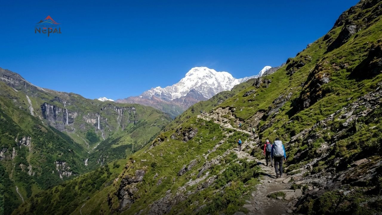
Day 4: Siti Village → Khaikot → Chirchire → Shimar → Bhalyakhola → Dhauliodhar → Api Base Camp
Trekking: 9–10 hours | Night Stay: Api Base Camp Accommodation: Proper food and stay facilities confirmed (Hotels)
This is the longest and most demanding day of the trek and the most rewarding. The trail from Siti Village to Api Base Camp covers significant altitude gain and varied terrain, passing through multiple named settlements and landscape zones before delivering the extraordinary arrival at the base camp itself.
Siti to Khaikot: The trail continues ascending from Siti through increasingly alpine terrain. Khaikot is a small settlement offering the last substantial community before the higher reaches. The views from this section begin to open dramatically, with the Api Himal massif becoming increasingly visible and dominating above the valley walls. The forest here transitions from subtropical to temperate rhododendrons, oaks, and birches in place of the subtropical species below.
Khaikot to Chirchire and Shimar: The trail passes through Chirchire a name suggesting the sound of birdsong, and apt given the richness of birdlife in this section. Shimar follows, offering the possibility of rest and water before the final push toward higher terrain. These are small communities, but their existence as waypoints reflects the deep historical use of these trails by local communities moving between altitude zones.
Shimar to Bhalyakhola: The gradient increases substantially. Bhalyakhola (“Bhalya Khola” the Bhalya stream/river) marks the entry into proper high-altitude terrain. The landscape here becomes starker and more dramatic rocky outcrops, glacial moraines beginning to appear, and the air noticeably thinner and colder than the valley below. The trail follows the river drainage upstream toward the mountain’s base.
Bhalyakhola to Dhauliodhar: Dhauliodhar serves as the final waypoint before the base camp an elevated area with expanding views. The name suggests “white ridge” or “white highland,” and from here the glacier and snowfields of Api Himal’s lower flanks become clearly visible. This is where many trekkers experience the first full emotional impact of the mountain’s scale.
Arrival at Api Base Camp (~4,200 m): The base camp itself is an open alpine environment at the foot of Api Himal an expanse of glacial terrain with the mountain rising dramatically above. The views here encompass not only Api (7,132 m) but also neighbouring peaks of the Gurans Himal range, with Nampa (6,757 m) and Saipal (7,031 m) visible from ridge positions nearby.
Accommodation at Api Base Camp has improved markedly in recent years. Proper hotels with meals are confirmed operational at the base camp a significant infrastructure development that has made the trek more accessible to non-camping trekkers. This is partly a result of growing local interest in tourism development and the advocacy of leaders like Mayor Balen Shah.
Wildlife note for Day 4: The higher elevations above Khaikot are prime snow leopard territory. While sightings cannot be guaranteed, the Api Nampa Conservation Area has documented snow leopard populations, and the upper reaches of this trail offer genuine wildlife encounter potential. Himalayan black bears, musk deer, and the brilliant Danphe (Himalayan Monal pheasant) are more commonly observed.
Day 5: Explore Api Base Camp and Surroundings → Return to Dhauliodhar for Night
Night Stay: Dhauliodhar Accommodation: Proper food and stay facilities confirmed
This is the acclimatization, exploration, and appreciation day arguably the most memorable day of the entire trek.
With the overnight stay at base camp behind you and a full day available, Day 5 offers the opportunity to explore the extraordinary alpine environment surrounding the base camp at a leisurely, deliberate pace.
What to explore from Api Base Camp:
Morning glacier walk: The lower glacier below Api Himal’s southern face is accessible on foot from the base camp and offers a direct encounter with the mountain’s raw geology crevassed ice, moraine rubble, glacial meltwater streams, and the constant sound of ice movement. Walking on and around a live Himalayan glacier is a visceral experience that no number of photographs adequately conveys.
Panoramic ridge viewpoints: Several ridge positions above and around the base camp offer expanded panoramic views of the surrounding peaks. On clear days, the view encompasses a stunning arc of Himalayan summits including Api, Nampa, and from the highest accessible ridges the distant white shapes of peaks extending into Tibet. The Dhawalpur Lake and surrounding alpine meadows are also worth exploring from base camp.
Kalidhunga Lake: A sacred glacial lake nestled in the rugged mountain landscape above the base camp, Kalidhunga Lake is a gem worth seeking out for those with energy and time. The lake holds spiritual significance for local communities and its setting surrounded by the raw stone and ice of the high Himalayas is otherworldly.
Wildlife watching: Dawn and dusk at altitude are prime wildlife observation periods. The open terrain around base camp allows distant views across rocky slopes where Himalayan fauna are most active. Binoculars significantly enhance this experience.
The mountain itself in full light: There is no substitute for simply sitting and watching Api Himal as the sun tracks across it through the day. The morning light on the eastern face, the midday clarity of the ridgeline, the alpenglow on the summit as the sun sets the mountain performs differently at every hour.
In the evening, return to Dhauliodhar for overnight accommodation, which allows a slightly lower-altitude sleep and the practical advantage of being one descent stage ahead for the following day’s long return walk.
Day 6: Dhauliodhar → Khaikot → Siti Village → Ghusa Village
Trekking: 9–10 hours | Night Stay: Ghusa Village / Siti Village Accommodation: Proper food and stay facilities Homestay
The return journey retraces the ascent route from Day 4, but descending reveals perspectives on the landscape that were different — or entirely obscured by fatigue and forward focus on the way up. The broadening views down the valley, the changing light from the opposite direction, and the relaxed pace of descent make this a fundamentally different experience from Day 4.
The long walk from Dhauliodhar back through Bhalyakhola, Shimar, Chirchire, and Khaikot is eased by the downhill gradient. The familiar waypoints from the ascent become landmarks of return rather than milestones of anticipation each one confirming progress back toward the warmth and hospitality of Siti Village.
Arriving at either Siti Village or Ghusa Village for the night, the homestay experience is, if anything, warmer on the return. Hosts who met you as strangers two days ago now receive you as familiar guests. The conversation over dinner is easier, the dal bhat more generous, and the evening passes in the particular contentment that follows a long day’s trekking completed successfully.
Day 7: Ghusa Village → Makarigaad (Trekking 2–3 hrs) → Makarigaad → Gokuleshwor (By Vehicle)
The trek’s final walking day is short and gentle a 2–3 hour descent from Ghusa Village back to Makarigaad following the now-familiar river trail. The mood is reflective: the landscapes that were entirely new on Day 3 are now known, and the walk has the quality of saying goodbye to a place that has given something important.
At Makarigaad, the trekking phase ends and the vehicular journey begins. Exit the Api Nampa Conservation Area at the checkpoint. Arrange transport from Makarigaad back to Gokuleshwor approximately 5 hours by jeep along the same mountain road that brought you here.
Night Stay: Gokuleshwor. After days of remote mountain living, Gokuleshwor’s guesthouses and local restaurants feel luxurious. The distinctive character of Far Western Nepal’s district headquarters busy, frontier-feeling, culturally distinct from Kathmandu is worth an evening of relaxed observation.
Day 8/9: Gokuleshwor → Attariya → Kathmandu (By Vehicle)
OR: Gokuleshwor → Dhangadhi (By Vehicle) → Dhangadhi → Kathmandu (Flight)
The return to Kathmandu mirrors the outward journey. The flight option (Gokuleshwor → Dhangadhi by vehicle, approximately 8–9 hours; Dhangadhi → Kathmandu by flight, 1 hour) is faster and strongly recommended for those with limited time. The full overland return (Gokuleshwor → Attariya → Kathmandu, approximately 18–20 hours) is possible for those with time and a preference for seeing the entire Far Western landscape one final time.
Permits Required for Api Base Camp Trek (2026)
Two mandatory permits are required for trekking in the Api Nampa Conservation Area:
1. Api Nampa Conservation Area Permit (ANCAP)
The primary permit for the entire trekking region. The Api Nampa Conservation Area covers over 1,903 sq km in Darchula District and requires a conservation permit before entry. The permit fee is approximately USD $30–50 for foreign nationals in 2026, with lower fees for SAARC nationals (Indian, Bangladeshi, Sri Lankan, etc.) and Nepali citizens.
2. TIMS Card (Trekkers’ Information Management System)
The standard trekking registration card required for all major trekking routes in Nepal. TIMS fees for the Api Base Camp route:
- Foreign nationals (group trekkers): NPR 1,000 (~USD $7.50)
- Foreign nationals (independent trekkers): NPR 2,000 (~USD $15)
- SAARC nationals (group trekkers): NPR 300
- SAARC nationals (independent trekkers): NPR 600
- Nepali nationals: NPR 100–200
Where to obtain permits: Both the ANCAP and TIMS card can be obtained at the Nepal Tourism Board office in Kathmandu (Bhrikutimandap, near Thamel) or through your registered trekking agency. Obtain these permits before leaving Kathmandu do not attempt to arrange them at Makarigaad or on the trail.
Important 2026 note: A licensed guide is now mandatory for all trekking routes in Nepal’s protected areas, including the Api Nampa Conservation Area, per regulations implemented in 2023. This requirement is enforced at trail checkpoints. Your guide can assist with permit logistics and will carry copies of all documentation.
How to Reach the Api Base Camp Trailhead
Option 1: Flight to Dhangadhi + Drive (Recommended)
Step 1 — Fly Kathmandu (KTM) to Dhangadhi (DHI) Several airlines operate the Kathmandu–Dhangadhi route, including Buddha Air and Shree Airlines. Flight time is approximately 1 hour. Book in advance, particularly during spring and autumn trekking seasons. One-way fares range from NPR 5,000–12,000 (~$37–$90) depending on airline and booking timing.
Step 2 — Drive Dhangadhi to Gokuleshwor The drive from Dhangadhi to Gokuleshwor is approximately 8–9 hours by private jeep or shared vehicle. The route passes through Attariya (about 30 minutes from Dhangadhi) and then heads north through increasingly dramatic mountain terrain toward Darchula District. Road quality improves significantly closer to Gokuleshwor compared to some stretches of the Far Western highway network.
Step 3 — Drive Gokuleshwor to Makarigaad Approximately 65 kilometres and 5 hours from Gokuleshwor to Makarigaad, following the Mahakali River through narrow mountain roads. This final approach to the trailhead passes some of the most dramatic river gorge scenery of the entire journey.
Option 2: Full Overland from Kathmandu
The complete overland route from Kathmandu follows the Mahendra Highway westward across the Terai to Attariya (~700 km, approximately 14–16 hours), then north to Gokuleshwor (additional 8–9 hours from Attariya via Darchula road). This two-day drive is manageable for those who prefer road journeys and want to witness Nepal’s geographic transition from the subtropical east to the arid far west.
Option 3: Via India The Nearest Route for Indian Trekkers
For Indian trekkers specifically, Darchula District is accessible from the Indian side via Pithoragarh and Dharchula (Indian border town), making this one of the most geographically convenient major Himalayan treks for Indian nationals. The proximity to the Indian border (the Mahakali River effectively forms the boundary) means trekkers from Uttarakhand, Delhi, and other northern Indian cities may find the Api Base Camp route significantly more accessible than Kathmandu-based alternatives. Immigration formalities apply at the border crossing.
Best Season to Visit Api Base Camp
The Api Base Camp trek, like most Himalayan routes, has clearly defined optimal seasons and periods to avoid.
Spring Season: March to May ⭐ Recommended
Spring is arguably the finest season for the guide to visit Api Base Camp. March–May brings:
- Clear skies with excellent mountain visibility
- Rhododendron forests in full bloom at mid-altitude (March–April) the most visually spectacular time for the forested sections
- Warming temperatures at altitude but still-cold nights that keep the air crystal clear
- Active wildlife as animals return to higher elevations after winter
The best weeks are typically mid-March through mid-May. Late May can bring pre-monsoon cloud build-up.
Autumn Season: September to November ⭐ Recommended
Post-monsoon autumn is Nepal’s universally best trekking season, and the Api Base Camp route is no exception:
- September and October offer the clearest mountain views of the year
- Post-monsoon green lushness makes the lower forest sections particularly beautiful
- Stable weather with minimal rain or snow at trekking altitudes
- Cool temperatures ideal for long trekking days
- October and November are the peak months for the best combination of weather and views
Monsoon Season: June to August ✗ Not Recommended
The monsoon brings heavy rainfall, leech-infested trails, landslide risk on the mountain roads, and cloud cover that blocks mountain views. The drive to Makarigaad can be severely disrupted by monsoon landslides on the approach roads. Most trekking agencies do not operate Api Base Camp itineraries during this period.
Winter Season: December to February Challenging but Possible
Winter trekking is possible for experienced, well-equipped trekkers. The base camp area receives significant snowfall from December onwards, and the high sections of the trail (above Khaikot) may require crampons and additional cold-weather gear. The lower reaches of the trail remain walkable, but temperatures at Api Base Camp drop well below -10°C at night. Very few trekkers visit in winter, offering an experience of genuine solitude but requiring serious preparation.
What to Pack: Essential Gear for Api Base Camp Trek
The Api Base Camp trek is a moderate-to-challenging route that reaches approximately 4,200 metres. The accommodation (confirmed homestays and basic hotels throughout the route) means camping equipment is not required, but high-altitude cold-weather gear is essential for the base camp section.
Clothing:
- Moisture-wicking base layers (2–3 sets)
- Mid-layer fleece or softshell jacket
- Down or synthetic insulation jacket (essential for base camp nights)
- Waterproof outer shell jacket and trousers
- Trekking trousers (2 pairs)
- Warm hat, sun hat, gloves, and spare gloves
- Wool or synthetic trekking socks (5–6 pairs)
Footwear:
- Well-broken-in waterproof trekking boots with ankle support (mandatory)
- Lightweight camp shoes or sandals for evenings at lodges
Equipment:
- Trekking poles (strongly recommended for the long Day 4 and Day 6 ascent/descent)
- Sleeping bag rated to at least -10°C (nights at base camp can be very cold even in season)
- Headlamp with spare batteries
- Sunglasses with UV protection (mandatory at altitude)
- Sunscreen SPF 50+
- Water purification tablets or filter (critical in remote sections)
- Blister treatment, basic first aid kit, altitude medication (diamox — consult your doctor)
- Personal medications and any prescription drugs
- Power bank (electricity is limited along the trail)
Documents to carry:
- Original passport
- Api Nampa Conservation Area Permit
- TIMS Card
- Travel insurance documents (with helicopter evacuation coverage)
- Nepal visa documents (if applicable)
Accommodation Along the Api Base Camp Route
One of the most significant developments in 2026 is the improved accommodation situation along the entire Api Base Camp route a direct result of infrastructure investment and growing interest following Mayor Balen Shah’s visit and promotion.
| Location | Accommodation Type | Food Available | Notes |
|---|---|---|---|
| Makarigaad | Guesthouses/Teahouses | Yes | Trek start/end point |
| Ghusa Village | Homestays | Yes traditional meals | Warm, local hospitality |
| Siti Village | Homestays | Yes proper food confirmed | Good overnight base |
| Khaikot | Basic teahouses | Limited | Rest stop primarily |
| Dhauliodhar | Basic hotels/lodges | Yes | Confirmed operational |
| Api Base Camp | Hotels | Yes proper food confirmed | Recently improved |
| Gokuleshwor | Guesthouses/Hotels | Yes | District headquarters |
Food on the trail: Expect traditional Far Western Nepali cuisine throughout dal bhat (lentil soup with rice) is the staple, accompanied by vegetable curries, local pickles, and seasonal produce. The organic, locally-grown character of the food is one of the trek’s genuine pleasures. Fresh meat may be available in villages but is not reliable at higher elevations.
Costs and Budget for Api Base Camp Trek (2026)
The Api Base Camp trek is genuinely affordable by Himalayan trekking standards, particularly given the extraordinary experience it delivers.
Approximate costs for independent trekkers (per person):
| Expense | Estimated Cost |
|---|---|
| Kathmandu to Dhangadhi flight | NPR 6,000–12,000 (~$45–$90) one-way |
| Dhangadhi to Makarigaad by jeep | NPR 3,000–5,000 shared / NPR 15,000–20,000 private |
| Api Nampa Conservation Area Permit | ~USD $30–$50 (foreign); lower for SAARC |
| TIMS Card | NPR 1,000–2,000 (foreign); NPR 300–600 (SAARC) |
| Licensed guide (per day) | NPR 2,500–3,500 per day |
| Porter (per day, optional) | NPR 1,500–2,000 per day |
| Accommodation (per night) | NPR 300–800 at homestays; NPR 800–2,000 at lodges |
| Meals (per day, 3 meals) | NPR 1,500–2,500 per day |
| Total for 9-day trek (excluding Kathmandu costs) | NPR 35,000–55,000 (~$260–$410) |
Full package tours arranged through Kathmandu-based trekking agencies typically cost USD $800–$1,500 per person for the complete Api Base Camp package including flights, permits, guide, porter, and accommodation substantially cheaper than comparable remote trek packages to Upper Mustang or Dolpo.
Safety and Responsible Trekking at Api Base Camp
Altitude: Api Base Camp at 4,200 metres is not the highest altitude encountered on popular Nepal treks (Everest Base Camp is at 5,364 m), but it is still high enough for altitude sickness (Acute Mountain Sickness AMS) to affect unacclimatized trekkers. The itinerary’s Day 4 involves significant rapid altitude gain. Monitor yourself and your companions for symptoms of AMS: headache, nausea, dizziness, fatigue. If symptoms are severe, descend immediately.
Day 4 preparedness: The 9–10 hour Day 4 (Siti Village to Api Base Camp) is the most physically demanding day of the trek. Leave before dawn to maximize daylight. Carry adequate water (a minimum of 2–3 litres), high-energy snacks, and warm layers even if the morning is mild.
Guide requirement: A licensed guide is mandatory for all Nepal trekking in protected areas under 2023 regulations. Beyond legal compliance, a local guide on the Api Base Camp route is genuinely valuable for navigation in sections where the trail is unclear, for cultural translation, for wildlife identification, and for safety management in a region with very limited mobile network coverage and virtually no rescue infrastructure.
Travel Insurance: Helicopter rescue from the Api Base Camp area would be extremely expensive potentially USD $5,000–$10,000+. Comprehensive travel insurance with emergency medical evacuation coverage is absolutely non-negotiable for this trek. Ensure your policy specifically covers trekking to 4,200 metres.
Environmental responsibility: The Api Nampa Conservation Area is one of Nepal’s most pristine protected environments. Pack out all waste. Do not disturb wildlife. Respect vegetation and do not light campfires except in designated areas. The communities along this trail are hosting trekkers in good faith respect their homes, their temples, and their farming land.
Frequently Asked Questions
How difficult is the Api Base Camp trek?
The trek is rated moderate to challenging. The major challenge is not altitude (4,200 m is manageable for reasonably fit trekkers) but the long trekking days particularly Day 4 and Day 6, each requiring 9–10 hours of walking. Good fitness, previous trekking experience, and quality footwear are strongly recommended.
Do I need previous high-altitude experience for Api Base Camp?
Previous trekking experience is recommended. While the trek does not require technical climbing skills, the combination of remote terrain, limited rescue infrastructure, and long daily distances makes previous multi-day trekking experience valuable preparation.
When is the best time to visit Api Base Camp?
October–November (autumn) and March–May (spring) are the best seasons. September 21 marks the beginning of the best post-monsoon window. Spring brings rhododendron blooms; autumn brings the clearest mountain views.
Can Indian tourists trek to Api Base Camp?
Yes. The Api Nampa Conservation Area is accessible to all nationalities including Indian nationals. Indian trekkers may also consider entering via the Dharchula border crossing from Uttarakhand, which is geographically very close. SAARC nationals pay reduced permit fees. Indian nationals must hold a valid Indian passport (Aadhaar alone is insufficient for official entry).
Is it possible to do the Api Base Camp trek without a guide?
No. A licensed guide is now mandatory for trekking in all Nepal conservation areas under regulations effective from 2023. Beyond the legal requirement, the remote and sparsely marked nature of sections of the Api Base Camp trail makes a knowledgeable local guide genuinely essential for safety.
What is the mobile network coverage like on the Api Base Camp trek?
Mobile network coverage is unreliable to non-existent above Siti Village. Inform family members of your itinerary before departing. Many trekking agencies provide satellite communication devices for remote treks like Api Base Camp worth requesting when booking.
Why 2026 Is the Best Year to Visit Api Base Camp
Mayor Balen Shah’s visit and public promotion of Api Base Camp has catalysed genuine infrastructure improvements and growing awareness of this extraordinary trek. The homestay network has been formalized, accommodation at base camp has been improved, and the trail’s profile in Nepal’s media has risen substantially.
But the window during which this trek retains its essential character the emptiness, the authenticity, the feeling of genuine discovery is not unlimited. As more travelers follow the Balen Shah route and as Nepal’s tourism authorities increase investment in Far Western development, the Api Base Camp trek will eventually become better known.
In 2026, it remains Nepal’s best-kept trekking secret. The infrastructure is sufficient. The experience is extraordinary. The crowds simply do not exist.
This guide to visit Api Base Camp exists to help you get there while it still feels like the rest of the world forgot to notice.
For permits and trekking agency bookings, visit the Nepal Tourism Board at welcomenepal.com or in person at their Kathmandu office near Bhrikutimandap. For Dhangadhi flights, check Buddha Air (buddhaair.com) and Shree Airlines for current schedules and fares. For emergency consular assistance, contact the relevant embassy in Kathmandu.
