
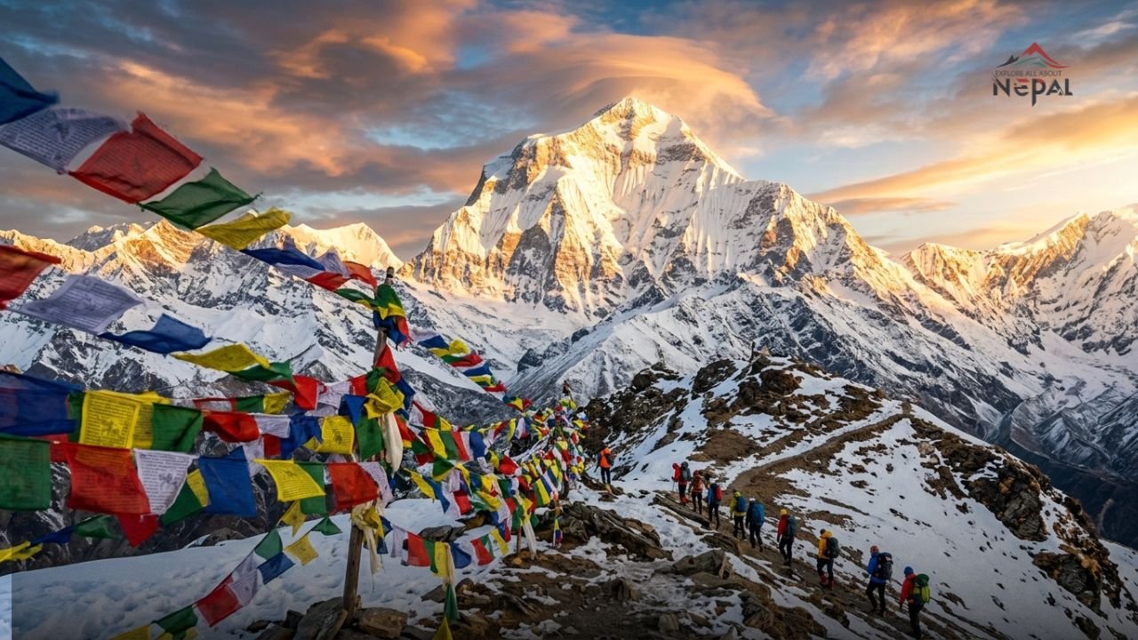
Dhaulagiri (Nepali: धौलागिरी; Sanskrit: Dhawala Giri, meaning “Dazzling White Mountain”) is the seventh highest mountain on Earth, standing at an elevation of 8,167 metres (26,795 feet) above sea level. Located in the Myagdi District of Gandaki Province, Nepal, Dhaulagiri is the highest peak contained entirely within a single country Nepal and the highest point of the Gandaki River basin.
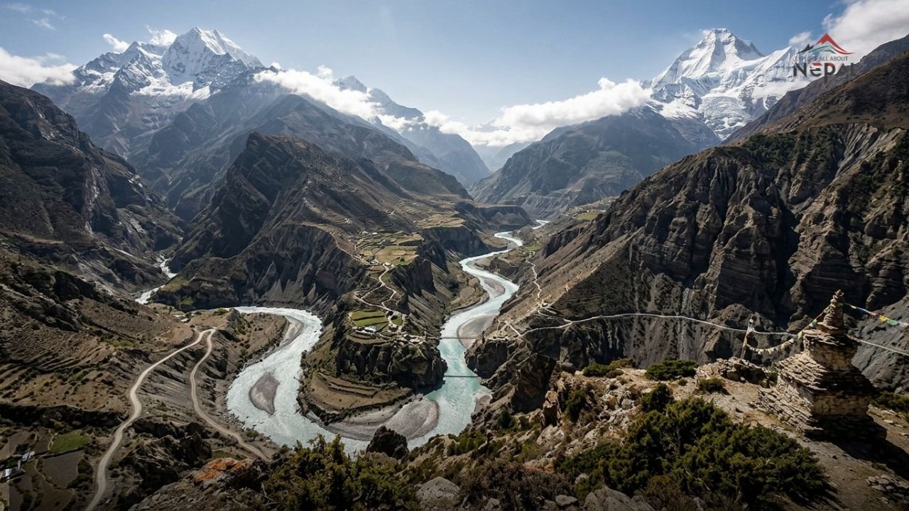
The mountain lies approximately 34 kilometres northwest of Pokhara and is separated from Annapurna I (8,091 m) to the east by the Kali Gandaki Gorge the deepest gorge on Earth. This extraordinary geographical pairing means that Dhaulagiri and Annapurna rise from the very bottom of the world’s deepest canyon in a display of vertical scale that is, by any objective measure, one of the most dramatic geological formations on the planet.
German mountaineers have long called Dhaulagiri the “Berg der Stürme” the Mountain of Storms a name that reflects its reputation for prolonged and severe weather cycles that have challenged and defeated even the most experienced mountaineers. The mountain holds the greatest vertical rise of any peak on Earth approximately 3,000 metres directly from the Kali Gandaki Gorge to the summit.
Quick Reference: Dhaulagiri at a Glance
| Fact | Detail |
|---|---|
| Elevation | 8,167 m (26,795 ft) |
| World Ranking | 7th highest mountain on Earth |
| Location | Myagdi District, Gandaki Province, Nepal |
| Coordinates | 28°41′48″N 83°29′35″E |
| Mountain Range | Dhaulagiri Himal (subrange of Himalayas) |
| Nearest City | Pokhara (~34 km southeast) |
| First Ascent | May 13, 1960 |
| First Ascent Team | Swiss-Austrian-Nepali expedition led by Max Eiselin |
| Standard Route | Northeast Ridge (Northeast Spur) |
| Base Camp Altitude | 4,750 m (Myagdi Khola valley) |
| Climbing Permit (2026) | USD $3,000 per person (spring) |
| Full Expedition Cost | USD $10,500–$14,600 (spring) |
| Death Rate | ~10–16% (historical; improving with modern logistics) |
| Conservation Area | Annapurna Conservation Area (ACAP) |
| District | Myagdi District |
| Best Climbing Season | Spring (March–May) and Autumn (Sept–Oct) |
Geography and Location
Where Is Dhaulagiri Located?
Dhaulagiri is situated in Myagdi District, Gandaki Province in the central-western Himalayas of Nepal. The mountain stands as the dominant peak of the Dhaulagiri Himal a massif that contains fifteen peaks above 7,000 metres, making it one of the most peak-dense mountain ranges in the world.
The Dhaulagiri massif is bounded to the east by the Kali Gandaki River gorge and the Annapurna Himal, to the north by the Tibet Autonomous Region of China, and to the west by the Myagdi Khola (the approach valley for expeditions). The main summit of Dhaulagiri I dominates the massif, with subsidiary peaks including Dhaulagiri II (7,751 m), Dhaulagiri III (7,715 m), Dhaulagiri IV (7,661 m), Dhaulagiri V (7,618 m), and Dhaulagiri VI (7,268 m) extending along the range.
The Kali Gandaki Gorge: The World’s Deepest
One of Dhaulagiri’s most remarkable geographical features is its relationship with the Kali Gandaki Gorge to its east. The gorge which runs between Dhaulagiri (8,167 m) to the west and Annapurna I (8,091 m) to the east is measured as the world’s deepest gorge, with a depth exceeding 5,571 metres from the highest flanking peaks to the river level at Tatopani (approximately 1,200 m elevation). This makes the gorge deeper than any other on Earth by a substantial margin.
Kali Gandaki Gorge
The Kali Gandaki has cut this gorge over millions of years as the river predates the Himalayan orogeny it was flowing before the mountains rose around it, maintaining its course even as the Himalayas uplifted, carving progressively deeper as the mountains grew. This ancient river gorge is the primary trekking corridor for the Annapurna Circuit, the world’s most celebrated multi-day trek, and the route from which Dhaulagiri’s southern face is most dramatically viewed.
Geology of Dhaulagiri
Dhaulagiri’s story begins not in the clouds, but beneath ancient ocean waves. The summit’s limestone and dolomite formations tell an extraordinary tale of geological transformation. These rocks, now crowning one of Earth’s highest peaks, were once part of the ocean floor a testament to the incredible forces that shaped the Himalayas.
The Himalayas were formed by the collision of the Indian subcontinent with the Eurasian plate beginning approximately 50 million years ago. The Tethys Sea, which previously separated the two landmasses, was compressed and uplifted to form the highest mountain ranges on Earth. Marine sedimentary rocks found at Dhaulagiri’s summit are evidence of this ocean floor origin limestone and dolomite deposited on the Tethyan seabed now form the peak of the seventh highest mountain in the world.
The mountain’s geological structure reflects this tectonic history in its layered rock formations, the characteristic frost-shattering of exposed faces that produces the mountain’s notorious rockfall hazard, and the extensive glaciation that covers its upper reaches.
Dhaulagiri: Name, Etymology and Historical Significance
Etymology
The name Dhaulagiri derives from two Sanskrit words:
- Dhawala (धवल) — meaning dazzling, white, or shining
- Giri (गिरि) — meaning mountain
Combined: “The Dazzling White Mountain” or simply “White Mountain.”
This name, earned from the mountain’s characteristic appearance its summit perpetually blanketed in snow and glacial ice that catches and reflects sunlight with extraordinary brilliance has been applied to this peak by the peoples of the surrounding valleys since antiquity.
Historical Perception
For several decades in the early 19th century, Dhaulagiri was widely believed to be the highest mountain on Earth. European geographers and explorers, working from limited survey data in the Himalayan region, estimated Dhaulagiri’s elevation to be higher than any other known peak. This belief held from approximately 1808 until the 1840s, when the Great Trigonometrical Survey of India produced more precise measurements that first identified Kangchenjunga and later Mount Everest as taller peaks.
The eventual recognition that Dhaulagiri was not the world’s highest mountain did nothing to diminish its majesty. At 8,167 metres, it remains a peak of extraordinary challenge, beauty, and significance one that has claimed the lives of dozens of experienced mountaineers and eluded some of the greatest climbers who have ever lived.
Climbing History: The Long Road to the First Ascent
Early Attempts (1950–1959)
Dhaulagiri’s climbing history is a story of repeated defeat followed by historic triumph. Before the first successful ascent in 1960, seven major expeditions attempted the mountain and failed an extraordinary record that earned Dhaulagiri a reputation as perhaps the most obdurate of all the eight-thousanders.
1950 The French Reconnaissance: The first serious reconnaissance of Dhaulagiri was conducted by a French team that had initially planned to attempt it but pivoted to Annapurna I instead resulting in the first-ever ascent of an eight-thousander when Maurice Herzog and Louis Lachenal summited Annapurna on June 3, 1950. Their decision to turn to Annapurna after surveying Dhaulagiri’s forbidding defenses speaks volumes about the White Mountain’s apparent impregnability.
1953–1959 Seven Failed Expeditions: Swiss, Argentine, and Austrian teams made repeated attempts on various routes throughout the 1950s. The mountain defeated all of them. Its combination of extreme technical difficulty, notorious storm cycles, altitude, and complex approach logistics made it the most resistant of Nepal’s giants to human ambition.
The First Ascent: May 13, 1960
On 13th May 1960, after a resilient and incredible climb without oxygen, Kurt Diemberger, Peter Diener, Ernst Forrer, Albin Schelbert, and the Sherpas Nawang Dorje and Nima Dorje made it to the summit.
The successful 1960 expedition was led by Swiss mountaineer Max Eiselin and was notable for being one of the first truly international Himalayan expeditions bringing together climbers from Switzerland, Austria, Germany, Poland, and the United States under a single organizational structure. “This was an expedition which, under Swiss organisation, was the first international ascent of an 8,000-metre peak,” said Kurt Diemberger.
The Aircraft “Yeti”: What made the 1960 Dhaulagiri expedition uniquely remarkable beyond the summit success itself was its use of a small fixed-wing aircraft for logistical support. What made Eiselin’s 1960 expedition so different was a radical new idea. They would bring a small fixed-wing aircraft, a Pilatus Porter PC-6, all the way from Switzerland for logistical support.
It was the first time that the Nepalese government permitted a light aircraft to land men and supplies on the glaciers and snowfields of the Himalaya. Swiss pilots Ernst Saxer and Emil Wick (also the mechanic) flew the plane, which was named the Yeti.
The Yeti aircraft crashed on May 5, 1960, during operations a setback that the team overcame by relying on conventional ground logistics for the final push. Despite losing their aerial support, the expedition continued to the summit eight days later.
Ten days later, on May 23, Michel Vaucher and Hugo Weber also reached the summit. All climbed without supplemental oxygen, and with the exception of the 31-year-old Diener, all the summiters were in their twenties.
The significance of Dhaulagiri as the penultimate eight-thousander: Dhaulagiri was the penultimate eight-thousander climbed only Shishapangma in 1964 would follow.
Notable Subsequent Ascents and Tragedies
1969 Dhaulagiri’s Deadliest Year: In 1969, the Dhaulagiri massif witnessed an unprecedented death toll. Thirteen climbers from two expeditions died in what was the deadliest year in Dhaulagiri’s history. The tragedies occurred on Dhaulagiri I and Dhaulagiri IV, roughly 15km apart, involving American and Austrian teams.
Reinhold Messner’s Failed Attempt: Even the legendary climber Reinhold Messner, who was the first to climb all 14 eight-thousanders and the first to summit Everest solo and without an oxygen cylinder, failed on Dhaulagiri. This fact alone communicates the mountain’s exceptional difficulty a peak that defeated the greatest high-altitude mountaineer in history on his attempt.
October 2024 Five Russian Climbers Lost: The Mountain of Storms reputation is not historical: as recently as October 6, 2024, five Russian climbers vanished on the mountain, their bodies recovered two days later. Five Russian climbers who had been missing on Nepal’s Mount Dhaulagiri since the weekend were found dead. There had been no contact with the climbers, scaling the 8,167-m peak without Sherpa guides, since Sunday night, when they reached a height of 7,700 m. The tragedy served as a stark reminder that Dhaulagiri remains one of the most dangerous mountains on Earth in 2024 and 2025.
Total Summit Statistics (as of 2026)
The first successful ascent to Dhaulagiri’s summit occurred in 1960. Since then, more than 480 people have repeated this success on the same route. However, no one has ever climbed the mountain via its southern face.
The mountain’s total recorded ascents remain far fewer than those of Everest, K2, or Annapurna a reflection of both its objective difficulty and its relatively limited commercial expedition infrastructure compared to the more famous peaks.
Dhaulagiri Death Rate: How Dangerous Is It?
The Dhaulagiri death rate is among the highest of all eight-thousanders, placing it consistently in the top tier of Himalayan danger alongside Annapurna I, K2, and Nanga Parbat.
The mountain’s reputation for danger isn’t merely folklore it’s carved in stark statistics. With a summit-to-fatality rate of 16.2% as of 2007, Dhaulagiri demands the utmost respect. Between 1950 and 2006, 2.88% of expedition members attempting climbs above base camp never returned home, making it one of the deadliest peaks in the Himalayas.
In a 2026 comparative analysis of 8,000-metre peak fatality statistics: Annapurna I is currently at the top at 13.42%, just above Dhaulagiri. This positions Dhaulagiri as the second most dangerous eight-thousander in the current comparative fatality ratio data.
The primary causes of death on Dhaulagiri:
- Avalanches — The mountain’s notorious storm cycles deposit enormous quantities of snow on its upper faces and ridges, creating constant avalanche hazard. Many Dhaulagiri fatalities have resulted from avalanche burial.
- Falls — The Northeast Ridge’s technical sections, and particularly the descent in deteriorating weather or exhaustion, produce fall incidents. The 2024 Russian tragedy appeared to result from a roped fall.
- Altitude sickness and weather exposure — Dhaulagiri’s extreme and rapid weather changes, combined with the altitude’s physiological demands, create conditions where deterioration occurs very quickly.
- Frostbite and hypothermia — The “Mountain of Storms” designation reflects genuine meteorological reality: sustained hurricane-force winds at summit altitude produce wind-chill temperatures that overwhelm even the best modern insulation.
Important context on the death rate: The historical 16.2% summit-to-fatality ratio means that for every 100 successful summits recorded, approximately 16 fatalities have occurred not that 16% of all climbers who attempt the mountain die. The actual probability of death for any individual well-prepared, guided expedition on the standard route is lower than the headline statistic suggests, though still substantially higher than on Everest (~1%) or the Annapurna Circuit trek (near zero for healthy trekkers).
Modern improvements in weather forecasting, high-altitude medicine, expedition logistics, and rescue infrastructure have reduced though not eliminated Dhaulagiri’s danger. The October 2024 Russian tragedy involved climbers attempting the mountain without Sherpa guides, highlighting that the mountain’s historic dangers remain fully present for those who do not engage appropriate support.
Climbing Dhaulagiri: Complete Expedition Guide (2026)
Is Dhaulagiri Difficult to Climb?
Yes Dhaulagiri is one of the most technically demanding and psychologically challenging eight-thousanders in the world. It is not a peak for beginners or for climbers whose primary experience is on commercial Everest expeditions with full logistical support. Most successful ascents follow the Northeast Ridge route, established during the first ascent. This route, while still extremely challenging, offers the most reasonable path to the summit.
Prerequisites recommended by experienced Dhaulagiri expedition operators:
- Previous summit experience on at least one 7,000+ metre peak
- Technical ice and mixed climbing competence (Grade IV–V ice climbing)
- Experience with extended high-altitude camping and self-sufficiency
- High-altitude physiology assessment (tolerance to extreme altitude varies significantly between individuals)
- Excellent physical conditioning (minimum 6 months of targeted training recommended)
Standard Climbing Route: Northeast Ridge
The Northeast Ridge (Northeast Spur) is the standard “normal” route on Dhaulagiri and the route used for the 1960 first ascent. It is the route taken by the vast majority of successful expeditions.
Camp structure on the Northeast Ridge:
- Base Camp: 4,750 m (Myagdi Khola valley; accessed via a ~6-day approach trek from Beni)
- Camp 1: Approximately 5,800–6,000 m
- Camp 2: Approximately 6,400–6,600 m
- Camp 3: Approximately 7,100–7,400 m (along the ridge, with steep ice and snow; the most technically demanding section of the climb)
- High Camp / Summit Camp: Approximately 7,600–7,900 m
From Camp 3, the upper ridge demands sustained technical climbing on steep snow and ice with significant cornicing and wind exposure. Camp 3 is located along the ridge of the mountain towards the west with steep ice and snow climbing. Heading towards Camp 3 there will be frequent ups and downs. Climbers have to climb towards the East Ridge, where strong wind may challenge them before reaching Camp 3. This is the most difficult part of the Dhaulagiri Expedition.
The summit push from high camp typically takes 8–12 hours depending on conditions, fitness, and acclimatization state. Descents are frequently the most dangerous phase.
Other Climbing Routes
While the Northeast Ridge is the standard route, several other routes have been attempted on Dhaulagiri:
- South Face — No one has ever climbed the mountain via its southern face one of the last great unclimbed faces among the eight-thousanders
- Southeast Ridge — Attempted by the ill-fated 1969 American expedition; extremely technical
- Northwest Ridge — A less-frequented but partially completed route
- East Face — One of the most technically demanding objectives on the mountain
How Long Does It Take to Climb Dhaulagiri?
A standard Dhaulagiri expedition takes approximately 45–55 days from Kathmandu to Kathmandu, structured as follows:
- Days 1–2: Kathmandu arrival, expedition logistics, permit collection
- Days 3–8: Approach trek from Beni (or helicopter to base camp)
- Days 9–12: Base camp establishment (4,750 m)
- Days 13–45+: Acclimatization rotations, camp establishment, weather waiting, summit attempt(s), descent
- Final days: Return to Kathmandu
Most operators structure a 47-day expedition. The mountain’s storm cycles mean that weather waiting periods can extend significantly beyond planned schedules. The Dhaulagiri Expedition lasts almost 7 weeks (47 days).
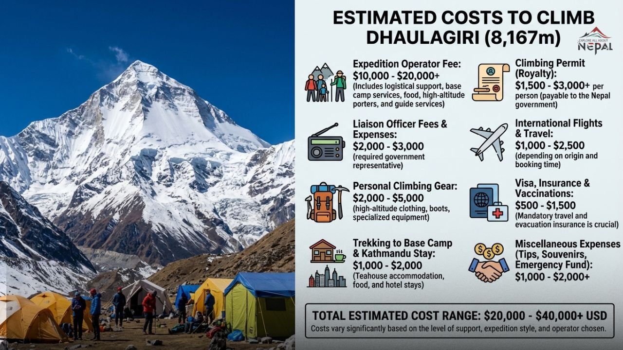
How Much Does It Cost to Climb Dhaulagiri?
The cost of a Dhaulagiri expedition in 2026 reflects significant increases in the Nepal government’s climbing permit fee following the September 2025 revision:
How Much Does It Cost to Climb Dhaulagiri
Nepal Government Climbing Permit (2026): Kanchenjunga (8,598 m), Lhotse (8,516 m), Makalu (8,463 m), Cho Oyu (8,201 m), Dhaulagiri (8,167 m), Manaslu Expedition (8,163 m), and Annapurna (8,091 m) permit fees for climbing in Nepal now cost around USD $3,000 in the spring.
Full expedition package costs (2026):
| Service Level | Cost per Person |
|---|---|
| Full Expedition Service (Spring) | USD $14,600 |
| Base Camp Service (Spring) | USD $8,500 |
| Budget/Self-organized expedition | USD $10,500–$12,000 |
The Dhaulagiri Expedition costs USD $14,600 per person for Full Expedition Service (Spring) and USD $8,500 for Base Camp Service (Spring).
What full expedition packages typically include:
- Nepal climbing permit ($3,000)
- Liaison officer fees
- Base camp accommodation and catering
- High-altitude Sherpa climbing support
- Fixed rope installation on technical sections
- Oxygen systems (bottles, masks, regulators) if selected
- Helicopter evacuation insurance
- Kathmandu accommodation (pre and post expedition)
- All meals from arrival in Nepal to departure
- Internal transport to and from trailhead
Additional costs not always included:
- International flights to Kathmandu
- Personal climbing equipment (boots, suits, harness, ice tools) $5,000–$10,000
- Personal travel insurance with helicopter rescue and repatriation coverage
- Gratuities for Sherpa and support teams
Best Seasons to Climb Dhaulagiri
Spring (March–May) Primary Season: Spring is the most popular and most successful climbing window for Dhaulagiri. The jet stream typically moves north of the Himalayas in April and May, reducing wind speeds and creating the brief stable weather windows that allow summit attempts. The spring season sees the greatest concentration of expeditions and the most developed fixed-rope infrastructure on the standard route.
Autumn (September–October) Secondary Season: The post-monsoon autumn window is shorter than spring but provides a genuine second opportunity for Dhaulagiri. The season is less crowded than spring, which can be an advantage for experienced teams who prefer lower camp congestion. Permit fees are almost double in winter and autumn compared to previous years following the 2025 restructuring.
Winter (December–February) Extreme expeditions only: Winter climbing on Dhaulagiri is one of the most serious undertakings in high-altitude mountaineering. Summit temperatures below -50°C with wind speeds exceeding 150 km/h are documented. Only the most elite and specifically equipped teams have ever attempted Dhaulagiri in winter.
Monsoon (June–August) Not recommended: Monsoon conditions make Dhaulagiri climbing essentially impossible for most expeditions. Snow loading creates extreme avalanche conditions across all routes.
Who Has Climbed Dhaulagiri?
First summiters (May 13, 1960): Kurt Diemberger (Austria), Peter Diener (Germany), Ernst Forrer (Switzerland), Albin Schelbert (Switzerland), Nawang Dorje Sherpa (Nepal), and Nima Dorje Sherpa (Nepal) part of the Swiss-Austrian-Nepali expedition led by Max Eiselin.
Kurt Diemberger holds the distinction of being the only person alive who has made first ascents on two eight-thousanders: Kurt Diemberger is the only living person who has made the first ascents on two mountains over 8,000 metres: Broad Peak in 1957 and Dhaulagiri in 1960. In 2013, he won the Piolet d’Or Lifetime Achievement Award. As of 2026, Diemberger is 94 years old.
Notable subsequent summiters include:
- Various Sherpa climbers who have achieved multiple Dhaulagiri summits
- Elite alpinists completing the 14 eight-thousanders project
- Reinhold Messner summited Dhaulagiri on a later attempt after his initial failure (as part of his 14 eight-thousanders project completed in 1986)
Trekking to Dhaulagiri: The Dhaulagiri Circuit Trek
What Is the Dhaulagiri Circuit Trek?
The Dhaulagiri Circuit Trek is one of Nepal’s most remote, demanding, and spectacular long-distance trekking routes a complete circumnavigation of the Dhaulagiri massif that crosses two high Himalayan passes and camps in some of the most remote alpine terrain accessible to non-technical trekkers anywhere in the world.
A challenging camping trek that brings you close to the foothills of the world’s seventh-highest mountain and encircles Mt. Dhaulagiri I along several passes and high Himalayan rugged terrain. The 16-day Dhaulagiri Trek itinerary covers the unexplored shadow Himalayan landscape, alpine meadow, and several high passes, including French Pass (5,360 m) and Dhampus Pass (5,240 m).
Dhaulagiri Circuit Trek: Key Facts
| Detail | Information |
|---|---|
| Duration | 15–20 days (depending on itinerary) |
| Total Distance | Approximately 170–180 km |
| Maximum Elevation | French Pass: 5,360 m |
| Key Passes | French Pass (5,360 m) and Dhampus Pass (5,240 m) |
| Trek Style | Camping (mandatory in remote sections; no teahouses) |
| Base Camp Altitude | Dhaulagiri Base Camp: 4,750 m |
| Start/End Point | Beni / Darbang (from Pokhara) to Jomsom or Marpha |
| Permits Required | ACAP Permit (NPR 3,000) + TIMS Card + Dhaulagiri Restricted Area Permit (USD $20/week) |
| Group Cost | USD $1,500–$2,700 per person |
| Difficulty | Strenuous / Expert |
| Best Season | Spring (March–May) and Autumn (Sept–Nov) |
Dhaulagiri Circuit Trek Route Overview
The trek begins with a 3–4 hour drive from Pokhara to Beni Bazaar (or Darbang), the effective starting point for the approach. From Beni, the trail ascends through the Myagdi Khola valley, passing through the settlements of Darbang, Dharapani, Muri, and Chariban before reaching the expedition infrastructure of the lower mountain.
Key stopping points and highlights:
Italian Base Camp (3,660 m): Named after Italian expeditions that established it as a standard waypoint on Dhaulagiri approaches. The first high-altitude camping site, offering initial views of the mountain’s immense western face.
Japanese Base Camp (4,200 m): Continuing up the valley, this camp named after Japanese expedition teams provides the first dramatic close-up views of the Dhaulagiri massif. The scale of the mountain at this elevation is genuinely shocking.
Dhaulagiri Base Camp (4,750 m): The main expedition base camp, set in a glacial valley with direct views of the Northeast Ridge and surrounding icefall. Camping at the main Dhaulagiri Base Camp surrounded by glaciers and icefalls. Trekkers who reach base camp even without climbing ambitions experience the mountain’s overwhelming vertical presence from a position that very few humans have ever occupied.
Chhondarban Glacier: The route to French Pass crosses this glacier, the trail to the north side of Chhondarban Glacier then climbs the steep hillside above the glacier. Following the zig-zag trail and across moraines, the route leads up to French Pass which offers a 360-degree view of surrounding mountain ranges.
French Pass (5,360 m): The highest point of the trek and the most technically demanding section a steep ascent on snow and rock that rewards with extraordinary panoramic views. On clear days, the view from French Pass encompasses Dhaulagiri I and its subsidiary peaks, the Annapurna range, and the immense plateau of the Hidden Valley below.
Hidden Valley (4,900–5,200 m): A vast high-altitude Himalayan plateau reaching the Hidden Valley is a surreal experience, offering a sense of detachment from the modern world that is rare to find elsewhere. This remote alpine basin sees very few human visitors and has the quality of absolute wilderness snow-covered, wind-swept, and utterly silent.
Dhampus Pass (5,240 m): The second high pass, connecting the Hidden Valley to the Kali Gandaki drainage and the Mustang region. The Dhampus Pass offers an awesome view of the Dhaulagiri and Annapurna ranges, and also of the Mustang Valley.
Yak Kharka (4,036 m): The descent from Dhampus Pass leads to this high-altitude pastoral area where yaks graze in summer, and the first signs of human habitation after the extreme remoteness of the Hidden Valley.
Marpha and Jomsom (2,667–2,736 m): The trek concludes in the Kali Gandaki valley, joining the Annapurna Circuit at Marpha a beautifully maintained Thakali village famous for its apple orchards and distillery and continuing to Jomsom for a flight back to Pokhara.
Dhaulagiri Circuit vs. Annapurna Base Camp vs. Everest Base Camp
| Feature | Dhaulagiri Circuit | Annapurna Base Camp | Everest Base Camp |
|---|---|---|---|
| Duration | 15–20 days | 10–12 days | 12–14 days |
| Max Altitude | 5,360 m (French Pass) | 4,130 m (ABC) | 5,364 m (EBC) |
| Difficulty | Expert/Strenuous | Moderate | Moderate-Strenuous |
| Crowd Level | Very Low | High | Very High |
| Accommodation | Camping (remote sections) | Teahouses throughout | Teahouses throughout |
| Mountain Views | 20+ peaks including 3 eight-thousanders | Annapurna massif | Everest, Lhotse, Nuptse |
| Cultural Immersion | Magar, Gurung, Thakali villages | Gurung villages | Sherpa culture |
| Cost (approx.) | $1,500–$2,700 | $800–$1,500 | $1,200–$2,500 |
| Best For | Experienced trekkers seeking wilderness | First-time Himalayan trekkers | All levels; iconic experience |
Which is better ABC, EBC, or Dhaulagiri Base Camp Trek?
The answer depends entirely on what you’re seeking. For first-time Himalayan trekkers, the Annapurna Base Camp route offers stunning scenery with comfortable teahouse infrastructure. For iconic and easily recognised achievement, Everest Base Camp remains the world’s most famous trek. For experienced trekkers who want genuine wilderness, expedition-style challenge, zero crowds, and an experience that very few people will ever share the Dhaulagiri Circuit is objectively the most extraordinary of the three.
Dhaulagiri: Permits and Regulations for 2026
For Trekkers (Dhaulagiri Circuit Trek)
Three permits are required for the Dhaulagiri Circuit Trek:
1. Annapurna Conservation Area Permit (ACAP) Cost: NPR 3,000 (~USD $23) for foreign nationals; NPR 1,000 for SAARC nationals Available at the ACAP offices in Kathmandu (Bhrikutimandap) or Pokhara (ACAP office near Prithvi Narayan Campus)
2. TIMS Card (Trekkers’ Information Management System) Cost: NPR 1,000 (group trekkers); NPR 2,000 (independent trekkers) for non-SAARC nationals NPR 300 (group) / NPR 600 (independent) for SAARC nationals Available at Nepal Tourism Board offices in Kathmandu and Pokhara
3. Dhaulagiri Restricted Area Permit Cost: USD $20 per person per week Required for the sections of the circuit in restricted territory Available through the Department of Immigration in Kathmandu or through your trekking agency
For Climbers (Dhaulagiri Expedition)
The primary expedition permit is issued by Nepal’s Department of Tourism (Ministry of Culture, Tourism and Civil Aviation):
Dhaulagiri (8,167 m) permit fees for climbing in Nepal now cost around USD $3,000 in the spring (following September 2025 revision). Permit fees are almost double in winter and autumn. Additional expedition requirements:
- Liaison officer (mandatory; government-appointed; cost approximately USD $1,500–$2,500 for the expedition duration)
- Garbage deposit (refundable upon exit verification)
- Environmental cleanup fee
- Comprehensive expedition insurance with helicopter rescue and body repatriation coverage
Wildlife and Ecology of the Dhaulagiri Region
The Dhaulagiri Himal and its surrounding conservation area contain remarkable biodiversity across its extreme elevational range:
Mammals: The higher reaches of the Dhaulagiri region are habitat for the snow leopard (Panthera uncia) one of the world’s most elusive and endangered large cats. Snow leopard population surveys have documented individuals in the upper Myagdi Khola valley and around the circuit route, though sightings are rare and require patience and luck.
Other mammals recorded in the region include:
- Himalayan black bear (Ursus thibetanus) — found in forest zones up to approximately 3,500 m
- Musk deer (Moschus chrysogaster) — hunted historically for their musk gland; now protected
- Blue sheep / Bharal (Pseudois nayaur) — commonly seen on rocky slopes above 4,000 m
- Himalayan tahr (Hemitragus jemlahicus) — gregarious mountain ungulate; frequently encountered by trekkers
- Common leopard — present at lower elevations in the Myagdi valley forests
- Red panda (Ailurus fulgens) — found in bamboo and rhododendron forests at mid-altitude
Birds: The Dhaulagiri region is exceptional for birdwatching, particularly for Himalayan specialist species:
- Himalayan Monal (Lophophorus impejanus) Nepal’s national bird; brilliantly iridescent; common in the 3,000–4,500 m zone
- Blood pheasant (Ithaginis cruentus)
- Impeyan pheasant varieties
- Numerous raptor species including Lammergeier (bearded vulture), Golden eagle, and Himalayan griffon
- Snow pigeon (Columba leuconota) colonies frequently seen near the higher camps
Flora: The Dhaulagiri approach valley displays Nepal’s characteristic vertical vegetation zonation:
- Lower slopes: Subtropical mixed forest
- Mid-altitude: Rhododendron forest (spectacular bloom in March–April)
- Higher zones: Birch, juniper, and willow scrub
- Alpine meadows: Diverse wildflowers including gentians, primulas, and potentillas
- Above 4,500 m: Cushion plants, mosses, and lichens on moraine
How to Get to Dhaulagiri: Approach and Access
For Trekkers (Dhaulagiri Circuit)
Step 1 — Reach Pokhara From Kathmandu: 30-minute domestic flight (NPR 5,000–10,000) or 6–7 hour tourist bus journey (NPR 700–1,500)
Step 2 — Drive Pokhara to Beni / Darbang Beni Bazaar is approximately 3–4 hours by vehicle from Pokhara. From Beni, a further drive to Darbang (approximately 1 hour) reaches the effective trailhead.
Step 3 — Trek from Darbang The trek begins from Darbang (approximately 1,180 m) and gradually ascends through the Myagdi Khola valley.
For Climbers (Dhaulagiri Expedition)
The standard approach for expeditions is:
- Kathmandu to Pokhara (flight or road)
- Pokhara to Beni (vehicle, approximately 3–4 hours)
- Beni to Dhaulagiri Base Camp (6–8 day approach trek through the Myagdi Khola valley, passing through Darbang, Dharapani, Muri, Singu Chuli approach, and the glacier)
- Alternative: Helicopter from Pokhara to base camp (saves approximately 5–6 days; increasingly used by commercial expeditions)
Dhaulagiri in Culture and Literature
Dhaulagiri occupies a significant place in both the local cultural geography of Western Nepal and in international mountaineering literature.
In the local tradition of Myagdi and the surrounding districts, the mountain is not merely a geographical feature but a sacred entity a dwelling place of mountain deities whose favour must be sought before any ascent. Puja ceremonies conducted at base camp before expedition departures reflect this living spiritual relationship between climbers (including local Sherpas and high-altitude workers) and the mountain.
In mountaineering literature, Dhaulagiri features prominently in Kurt Diemberger’s writings about the 1960 first ascent among the finest expedition accounts in the genre and in numerous accounts of subsequent expeditions that illuminate both the mountain’s beauty and its terrible power. The 1969 tragedies, in which thirteen climbers from two expeditions died, produced accounts that remain sobering reading about the catastrophic potential of Himalayan storms.
FAQs
Which district is Dhaulagiri in?
Dhaulagiri is located in Myagdi District, Gandaki Province, Nepal. The mountain lies within the Annapurna Conservation Area (ACAP), which is managed by the National Trust for Nature Conservation of Nepal.
Is Dhaulagiri difficult to climb?
Yes Dhaulagiri is one of the most challenging eight-thousanders. It combines extreme weather, technical climbing on the upper Northeast Ridge, significant avalanche exposure, and a historical fatality rate that places it among the top three most dangerous 8,000-metre peaks. It is not appropriate for climbers without substantial previous high-altitude and technical climbing experience. The standard route (Northeast Ridge) demands competence at Grade IV–V ice climbing and strong altitude physiology.
Who has climbed Dhaulagiri?
The first ascent was made on May 13, 1960, by Kurt Diemberger (Austria), Peter Diener (Germany), Ernst Forrer (Switzerland), Albin Schelbert (Switzerland), Nawang Dorje Sherpa, and Nima Dorje Sherpa led by Max Eiselin. Since then, over 480 people have summited via the Northeast Ridge route. Reinhold Messner summited Dhaulagiri as part of his historic completion of all 14 eight-thousanders in 1986. No climber has ever successfully ascended the mountain’s formidable southern face.
How much does it cost to climb Dhaulagiri?
A full-service Dhaulagiri expedition in spring 2026 costs approximately USD $14,600 per person including the Nepal government climbing permit (now USD $3,000 following the September 2025 fee increase), Sherpa support, base camp services, and all expedition logistics. Budget expeditions with base-camp-only service cost approximately USD $8,500. Personal equipment (suits, boots, ice tools) adds a further USD $5,000–$10,000 for those without existing gear.
How long does it take to climb Dhaulagiri?
A standard Dhaulagiri expedition takes approximately 45–55 days from Kathmandu arrival to Kathmandu departure. This includes the 6–8 day approach trek, base camp establishment, acclimatization rotations on the lower mountain, weather-waiting periods, the summit push, and descent. The mountain’s storm cycles frequently extend expeditions beyond the planned schedule.
What is the Dhaulagiri death rate?
Dhaulagiri’s historical summit-to-fatality rate stands at approximately 10–16% depending on the time period analyzed consistently among the highest of all eight-thousanders. This means that for every 100 successful summits recorded, approximately 10–16 fatalities have occurred on the mountain. Current data positions Dhaulagiri as the second most dangerous eight-thousander by fatality ratio, just below Annapurna I (13.42%). The October 2024 tragedy, in which five Russian climbers died, illustrates that this danger remains fully present in the current era.
Which is the cheapest trek in Nepal?
For budget travelers, the Poon Hill Trek (3–5 days, approximately USD $200–$400 all-inclusive) is Nepal’s most affordable genuine Himalayan trekking experience. The Langtang Valley Trek (7–10 days, approximately USD $400–$700) offers excellent value for mountain scenery and cultural immersion. These routes use established teahouse networks with no camping requirement.
Which is the toughest trek in Nepal?
The Dhaulagiri Circuit Trek is widely considered the most physically and logistically demanding long-distance trek in Nepal, followed by the Upper Dolpo Circuit and the Kangchenjunga Base Camp Trek. The Dhaulagiri Circuit’s two 5,000+ metre passes, mandatory camping in remote sections without teahouse fallback, and extreme weather exposure distinguish it from other challenging Nepal treks.
Is Nepal costly for Indians?
Nepal is generally very affordable for Indian travelers due to the fixed exchange rate (1 INR = 1.60 NPR) and SAARC-preferential pricing on most Nepal tourism services. Trekking permit fees are substantially reduced for Indian nationals: the ACAP permit costs NPR 1,000 for SAARC nationals vs NPR 3,000 for others. TIMS cards cost NPR 300–600 for SAARC nationals vs NPR 1,000–2,000 for others. Daily accommodation and food costs in Nepal are roughly 30–40% lower than equivalent standards in Indian metro cities.
Which is better ABC or EBC or Dhaulagiri Base Camp?
The answer depends on your experience level and what you’re seeking:
- Annapurna Base Camp (ABC): Best for moderate-difficulty trekkers; comfortable teahouses; dramatic cirque of Annapurna peaks; 10–12 days
- Everest Base Camp (EBC): Most iconic; best for those seeking the famous experience; teahouses throughout; 12–14 days; crowded in peak season
- Dhaulagiri Base Camp: Best for experienced trekkers seeking genuine wilderness and the most dramatic mountain scenery; mandatory camping in upper sections; 15+ days; almost no crowds; the most demanding but arguably the most extraordinary of the three
Dhaulagiri: Essential Summary
Dhaulagiri is more than a mountain. It is one of Earth’s supreme geological achievements a peak that rises nearly 8.2 kilometres above sea level, 3 kilometres directly from the world’s deepest gorge, to a summit encased in ice and perpetually swept by storms powerful enough to defeat the greatest mountaineers who have ever lived.
For trekkers, the Dhaulagiri Circuit offers Nepal’s most remote, most demanding, and arguably most magnificent long-distance journey a complete circumnavigation of the White Mountain through landscapes that few humans have ever witnessed, across high passes that most experienced trekkers will list among the most extraordinary experiences of their lives.
For climbers, Dhaulagiri represents one of the Himalayan world’s supreme challenges a mountain that has resisted, defeated, and sometimes destroyed those who have underestimated it, while rewarding those who have approached it with appropriate respect, preparation, and patience.
In 2026, with the Dhaulagiri Circuit trek growing in reputation among the global trekking community and expedition operators offering increasingly professional and safe ascent packages, the White Mountain is more accessible than ever. But accessible is not the same as easy. It never will be.
For climbing permits and expedition operator registration, contact Nepal’s Department of Tourism at tourism.gov.np. For trekking permits (ACAP, TIMS, Restricted Area Permit), visit the Nepal Tourism Board at welcomenepal.com or their Kathmandu office at Bhrikutimandap. For Dhaulagiri Circuit Trek bookings, enquire with any TAAN (Trekking Agencies’ Association of Nepal) registered operator.
